Project Snapshot
Overview
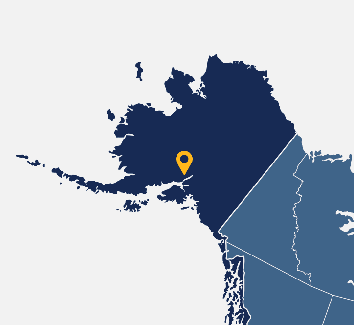
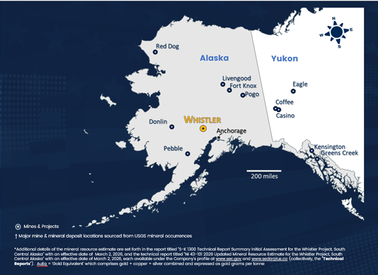
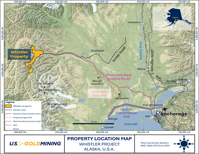
Whistler is a resource stage gold-rich copper porphyry exploration project located within the Alaska Range 105 miles (170 km) northwest of Anchorage, Alaska, USA. The regional land package comprising State of Alaska mining claims totals 53,700 acres (217 sq km).
The Whistler Project has indicated resources of 5.4 million gold equivalent ounces and inferred resources of 5.0 million gold equivalent ounces. Mineral resources have been estimated at three gold-copper porphyry deposits (Whistler, Raintree West and Island Mountain) and several additional geophysical and geochemical targets anomalies contain mineralized drill intersections that require follow-up drilling.
The Whistler Gold-Copper Project is supported by an existing base camp and gravel airstrip which are established for quick startup of field programs.
In March, U.S. GoldMining announced the results of the Preliminary Economic Assessment (or PEA), for its 100%-owned Whistler Gold-Copper Project.
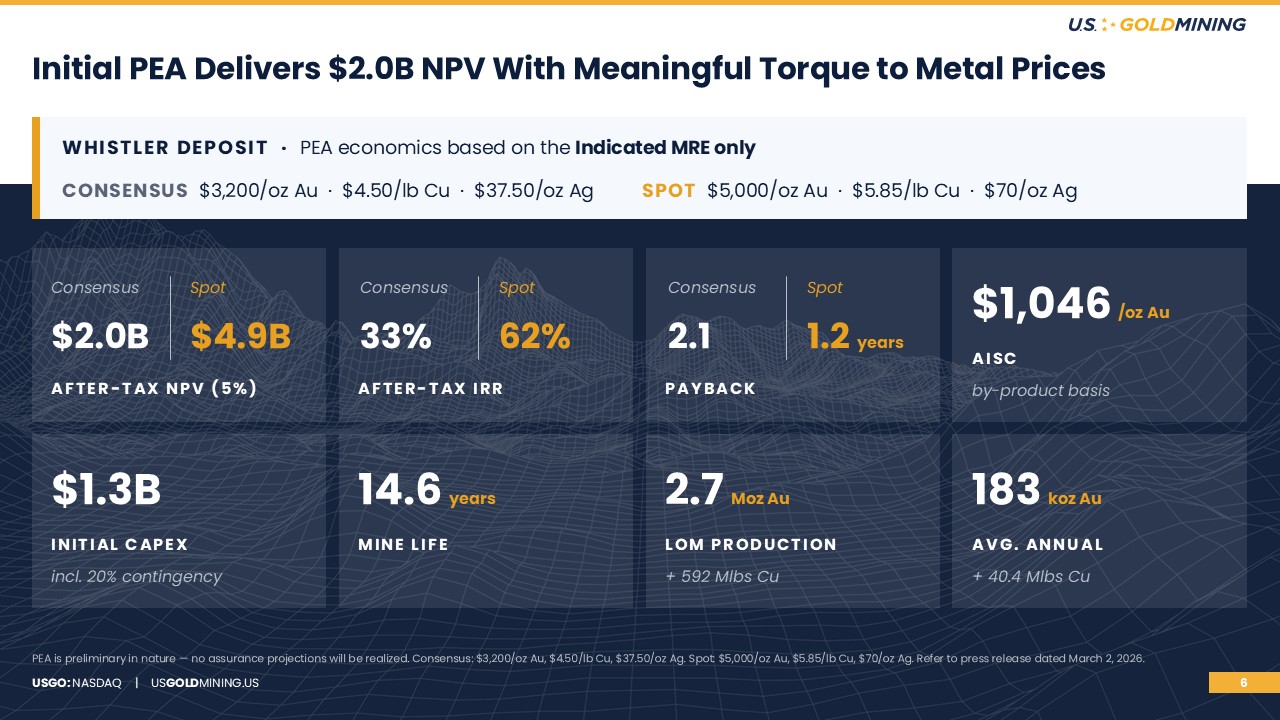
The PEA models the Whistler Project to produce over 2.6 million ounces of gold and almost 600 million pounds of copper, plus nearly 6.6 million ounces of silver. This equates to a life of mine total of almost 3.6M gold equivalent ounces at an average of 246,000 gold equivalent ounces per year. It envisions mining beginning with a higher-grade near-surface starter pit, driving early production of about 345,000 gold-equivalent ounces per year during the first three years. The PEA sets out, on a preliminary basis, a payback of about 2.1 years at base prices, or around 1.2 years utilizing base case prices of $3,200/oz Au, $4.50/lb Cu, and $37.50/oz Ag.
At spot prices of $5,000/oz Au, $5.85/lb Cu, and $70/oz Ag, Whistler’s after-tax Net Present Value (NPV) jumps to almost $4.9 billion dollars, with an attractive expected annualized return of investment in the project, or an Internal Rate of Return (IRR) exceeding 60%.
Whistler’s growth potential includes opportunity for U.S. GoldMining’s technical team to apply new regional geologic models to unlock value for Whistler, as well as following best practices in safety, environment and sustainability to optimize project advancement towards eventual future potential permitting and mine development.
Location
105 miles northwest of Anchorage, Alaska, USA
Property Size
53,700 acres (217 sq km)
Ownership
100%
Commodity
Gold, Copper
Infrastructure
Airstrip, camp, drill trails access Whistler and Raintree deposits; seasonal winter road.
Deposit Type
Gold-rich copper porphyry
Technical Reports
Preliminary Economic Assessment for Whistler Gold-Copper Project, Alaska
U.S. GoldMining Inc. announced the results of its initial economic assessment (the "PEA") for the 100% owned Whistler Gold-Copper Project, located 105 miles northwest of Anchorage, Alaska.
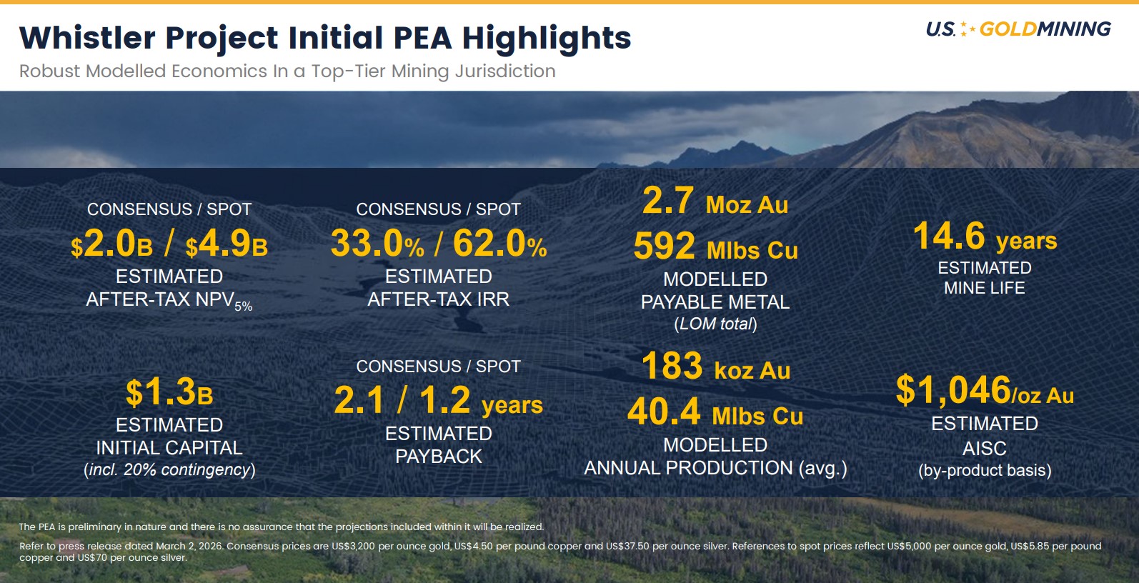
- Estimated after-tax net present value at 5% discount rate ("NPV5%") of $2.04B with an internal rate of return ("IRR") of 33.0% and initial payback of 2.1 years, utilizing base case prices of $3,200/oz Au, $4.50/lb Cu, and $37.50/oz Ag.
- At spot prices of $5,000/oz Au, $5.85/lb Cu, and $70/oz Ag, estimated after-tax NPV5% increases to approximately $4.88B with an IRR of 62.0% and initial payback of 1.2 years.
- Average annual production of 345,000oz gold equivalent (“AuEq”) per year estimated during the first three years of operations and total life of mine ("LOM") production of 3.6Moz AuEq, comprised of 2.6Moz gold, 6.9Moz silver, and 592Mlbs copper, over a 14.6 year mine life.
- Modeled LOM strip ratio of 2.2:1 (waste:processed material), and even lower at 1.5:1 in years 1-3.
- Estimated All-In Sustaining Costs ("AISC") of $1,046/oz Au (by-product basis) and initial capital costs of $1.28B.
- Contemplates open-pit truck-and-shovel operation with conventional process methods operating at a nominal throughput rate of 40,000 tonnes per day ("tpd"), which comprises a flotation and leach circuit recovering 88.9% gold and 77.8% copper.
- Further potential with additional deposits and exploration opportunities on district scale property.
Next Steps
- The Company is now planning immediate next steps, which may include further advancing the Project towards a possible pre-feasibility study ("PFS"). Additional work is required for the Company to determine whether to proceed to a PFS. Near term work programs could include commencement of waste rock geochemical characterization and storage optimization studies, and planning for comprehensive environmental baseline studies and stakeholder engagement. An expanded exploration program is currently in the early stages of planning, with a 2026 exploration program and budget expected to be announced in due course.
Technical Reports
Location
The Whistler Project is located in the Alaska Range approximately 105 miles (170km) northwest of Anchorage. The centre of the property is located at 152.57 degrees longitude west and 61.98 degrees latitude north.
The Whistler Project comprises 304 State of Alaska mining claims covering an aggregate area of approximately 53,700 acre (217km2) in the Yentna Mining District of Alaska. The claims are 100% owned by U.S. GoldMining.
An all season camp facility exists near the confluence of Portage Creek and the Skwentna River, approximately 15km southeast of the Rainy Pass Hunting Lodge. The camp is serviced with a 1,000m gravel airstrip for wheel-based aircrafts. The camp is equipped with diesel generators, a satellite communication link, tent structures on wooden floors, and several wood-framed buildings.
An all season camp facility exists near the confluence of Portage Creek and the Skwentna Riveradjacent to the Whisky Bravo 1,000m gravel airstrip
Geologic Setting and Mineralization
Alaskan geology consists of a collage of various terrains that were accreted to the western margin of North America as a result of complex tectonic plate interactions through most of the Phanerozoic. The southernmost Pacific margin is underlain by the Chugach–Prince William composite terrain, a Mesozoic-Cenozoic accretionary prism developed seaward from the Wrangellia composite terrain. It comprises volcanic arc batholiths and associated volcanic rocks of Jurassic, Cretaceous and early Tertiary age.
The Alaska Range represents a long-lived continental arc characterized by multiple magmatic events ranging in age from about 70 million years ago ("Ma") to 30Ma and associated with a wide range of base and precious metals hydrothermal sulphide bearing mineralization.
The geology of Whistler Project is characterized by a thick succession of Cretaceous to early Tertiary (ca. 97 to 65 Ma) volcano sedimentary rocks intruded by a diverse suite of plutonic rocks of Jurassic to mid-Tertiary age.
Two main intrusive suites are important in the Whistler Project area:
- The Whistler Igneous Suite comprises alkali-calcic basalt-andesite, diorite and monzonite intrusive rocks dated to approximately 76Ma, with minor extrusive volcanic equivalent rocks. The intrusions are commonly associated with gold-copper porphyry-style mineralization (e.g. Whistler Deposit).
- The Composite Suite intrusions vary in composition from peridotite to granite and their ages span from 67 to about 64Ma. Gold-copper veinlets and pegmatitic occurrences are characteristics of the Composite plutons (e.g. Estelle deposit (Nova Minerals) and the Muddy Creek prospect).
Early exploration work completed by Cominco, Kennecott, Geoinformatics and Kiska has discovered several gold-copper porphyry-style sulphide occurrences. The Whistler property contains numerous geophysical and geochemical anomalies suggesting that the project area is generally highly prospective for magmatic hydrothermal mineralization including potential for additional porphyry gold-copper deposits.
Current Activities:
- Historic drilling completed: 257 holes (70,247 m)
- Established resource includes gold (1.94 Moz gold Indicated & 4.7 Moz gold Inferred) and copper (422 Mlbs copper indicated & 711.4 Mlbs inferred) - See Resource Statement
- Database validation and creation of GIS and 3D data sets
- Geologic interpretation at deposit and mineral system scale
- Geophysical modelling and interpretationKP1
Geologic Setting and Mineralization
Alaskan geology consists of a collage of various terrains that were accreted to the western margin of North America as a result of complex tectonic plate interactions through most of the Phanerozoic. The southernmost Pacific margin is underlain by the Chugach–Prince William composite terrain, a Mesozoic-Cenozoic accretionary prism developed seaward from the Wrangellia composite terrain. It comprises volcanic arc batholiths and associated volcanic rocks of Jurassic, Cretaceous and early Tertiary age.
The Alaska Range represents a long-lived continental arc characterized by multiple magmatic events ranging in age from about 70 million years ago ("Ma") to 30Ma and associated with a wide range of base and precious metals hydrothermal sulphide bearing mineralization.
The geology of Whistler Project is characterized by a thick succession of Cretaceous to early Tertiary (ca. 97 to 65 Ma) volcano sedimentary rocks intruded by a diverse suite of plutonic rocks of Jurassic to mid-Tertiary age.
Two main intrusive suites are important in the Whistler Project area:
- The Whistler Igneous Suite comprises alkali-calcic basalt-andesite, diorite and monzonite intrusive rocks dated to approximately 76Ma, with minor extrusive volcanic equivalent rocks. The intrusions are commonly associated with gold-copper porphyry-style mineralization (e.g. Whistler Deposit).
- The Composite Suite intrusions vary in composition from peridotite to granite and their ages span from 67 to about 64Ma. Gold-copper veinlets and pegmatitic occurrences are characteristics of the Composite plutons (e.g. Estelle deposit (Nova Minerals) and the Muddy Creek prospect).
Early exploration work completed by Cominco, Kennecott, Geoinformatics and Kiska has discovered several gold-copper porphyry-style sulphide occurrences. The Whistler property contains numerous geophysical and geochemical anomalies suggesting that the project area is generally highly prospective for magmatic hydrothermal mineralization including potential for additional porphyry gold-copper deposits.
Current Activities:
- Historic drilling completed: 257 holes (70,247 m)
- Established resource includes gold (5.41 Moz gold Indicated & 4.97 Moz gold Inferred) and copper (992 Mlbs copper indicated & 391 Mlbs inferred) - See Resource Statement
- Database validation and creation of GIS and 3D data sets
- Geologic interpretation at deposit and mineral system scale
- Geophysical modelling and interpretation
Technical Report
Table 1‑1: Mineral Resource Estimate for the Whistler Project (Effective date: March 2, 2026)
| Class | Deposit | Cutoff Value |
ROM tonnage |
In-situ Grades | In-situ Metal | |||||||
| (US$/t) | (kt) | NSR (US$/t) | AuEq (g/t) | Au (g/t) | Cu (%) | Ag (g/t) | AuEq (koz) | Au (koz) | Cu (klbs) | Ag (koz) | ||
| Indicated | Whistler | 284,203 | 38.74 | 0.562 | 0.409 | 0.154 | 1.7 | 5,132 | 3,740 | 964,275 | 15,808 | |
| Raintree West-Pit |
13.40 | 10,332 | 35.63 | 0.517 | 0.420 | 0.076 | 4.8 | 156 | 128 | 15,356 | 1,321 | |
| Indicated Open Pit |
294,535 | 38.63 | 0.560 | 0.410 | 0.151 | 1.8 | 5,287 | 3,868 | 979,631 | 17,129 | ||
| Raintree West-UG |
$40 shell | 4,619 | 58.81 | 0.853 | 0.713 | 0.118 | 5.4 | 127 | 106 | 12,036 | 795 | |
| Total Indicated |
varies | 299,154 | 38.94 | 0.565 | 0.414 | 0.151 | 1.9 | 5,414 | 3,973 | 991,667 | 17,924 | |
| Inferred | Whistler | 4,967 | 38.37 | 0.556 | 0.433 | 0.115 | 1.2 | 89 | 69 | 12,549 | 192 | |
| Island Mountain |
187,283 | 29.04 | 0.421 | 0.376 | 0.043 | 0.9 | 2,535 | 2,263 | 178,368 | 5,299 | ||
| Raintree West-Pit |
13.40 | 18,780 | 37.83 | 0.548 | 0.471 | 0.057 | 4.3 | 289 | 252 | 19,475 | 1,927 | |
| Inferred Open Pit |
211,030 | 30.04 | 0.436 | 0.386 | 0.046 | 1.2 | 2,913 | 2,584 | 210,392 | 7,418 | ||
| Raintree West-UG |
$40 shell | 79,717 | 55.32 | 0.802 | 0.692 | 0.102 | 2.7 | 2,055 | 1,773 | 179,964 | 6,843 | |
| Total Inferred |
varies | 290,747 | 36.97 | 0.536 | 0.470 | 0.062 | 1.6 | 4,969 | 4,357 | 390,355 | 14,261 | |
Notes to the MRE:
- Mineral resources are not mineral reserves and do not have demonstrated economic viability. There is no certainty that all or any part of the mineral resources will be converted into mineral reserves.
- The mineral resource for the Whistler, Island Mountain, and the upper portions of the Raintree West Deposits have been confined by an open pit with “reasonable prospects of eventual economic extraction” using the following assumptions:
- metal prices of US$2,750/oz Au, US$4.35/lb Cu and US$30/oz Ag;
- payable metal of 94.8% payable for Au, 96.5% payable for Cu, and 88.2% payable for Ag;
- refining costs for Au of US$7.50/oz, for Ag of US$1.00/oz and for Cu of US$0.065/lb;
- off-site costs of US$165.65/t;
- royalty of 3% Net Smelter Return (NSR);
- pit slopes are 50 degrees;
- mining cost of US$2.75/t for waste and mineralized material; and
- processing costs of US$11.25/t, general and administrative costs of US$2.15/t.
- The open pits at Whistler and Island Mountain use the 150% NSR case, with the upper portion of Raintree West using the 100% NSR case. The lower portion of the Raintree West deposit has been constrained by a mineable shape within a “reasonable prospects of eventual economic extraction” shape using a $40.00/t cutoff value.
- Metallurgical recoveries are: 87.8% for Au, 75.4% for Cu, and 49.1% Ag.
- The NSR equation is: NSR ($/t)=(100%-3%)*((Au(g/t)*87.8%*$78.57/g) + (Cu%*75.4%*$3.88/lb*2204.62 + Ag(g/t)*49.1%* $0.77)).
- The gold equivalent equation is: AuEq=Au + Cu*0.9361 + 0.0055Ag.
- The specific gravity for each deposit and domain ranges from 2.76 to 2.91 for Island Mountain, 2.60 to 2.72 for Whistler with an average value of 2.80 for Raintree West.
- Numbers may not add due to rounding.


